HST/John Muir Trail: Day Nineteen, September 9

I camped pretty close to Muir Pass but it still took me longer than expected to get there. I was pretty tired at this point, mostly due to lack of sleep from being cold and wet every night. (and from the still-leaky sleeping pad that I had to use) Luckily the sky was clear…I just had to deal with the cold.

fullsizeoutput_10dca

The way to Muir Pass had lots of snow patches, presumably left by the storms of the previous few days.

IMG_2304 (1)

Before you get to Muir Pass on the south side you pass Helen Lake, named for the younger of John Muir’s two daughters.

fullsizeoutput_10dce

Helen Lake

I can’t tell you how excited I was to catch my first glimpse of the Muir Hut…it’s always oddly exciting to see a human-made structure in the wilderness, especially on a pass as remote as Muir Pass.

fullsizeoutput_10dcf

fullsizeoutput_10dd0

First glimpses of Muir Hut!

The Muir Hut was built in 1931 to commemorate John Muir and his work in preserving wilderness for future generations. It is made almost entirely of stone and blends in perfectly with its surroundings.

It’s one of the most beautiful places I’ve ever visited.

fullsizeoutput_10dd5

fullsizeoutput_10ddf

I was one of the first people to the hut that day so I had it (for the moment) completely to myself. I enjoyed the slowly warming sun, the company of marmots, and I contemplated the good fortune of just being human.

All in all, not a bad way to spend your birthday on the John Muir Trail, eh?

IMG_2325 (2)

Happy birthday to me!

Some notes on the pass crossing:

On the other side there are more lakes. There’s little McDermand Lake, named for Charles McDermand, a fly fisherman who wrote one of the bibles of the sport, “Waters of the Golden Trout Country”. Sadly, there are no trout in this lake, golden or otherwise.

fullsizeoutput_10dd7

McDermand Lake

Then you come to Wanda Lake, named for John Muir’s older daughter.

fullsizeoutput_10dda.jpeg

fullsizeoutput_10ddc

Wanda Lake

Then you come to what many consider the most beautiful part of the JMT, called Evolution Valley. I took zero photos in Evolution Valley. It was very hot and dry, and I was wiped out, so the rest of my birthday felt like a slog. It was pretty, for sure, but I wish I had planned to camp there, to see the sunrise or set in the valley, but as it was I hiked straight through it. Here’s a photo of the trail entering Evolution Valley.

IMG_2336

There’s so much more to see! Stay tuned.

IMG_2340 (2)

Evolution Lake

HST/John Muir Trail: Day Eighteen, September 8

My journal for September 8th is pretty blank because I tried to pack a lot in and didn’t have time to write. It just remember it was a crazy, tiring, wet and wild day and the journal notes that it was the first time I considered maybe going home without finishing. Entirely my fault, too. Here’s what happened.

IMG_2142 (2)

I started out from near the Leconte Ranger Station…yesterday was another cold, wet one, remember? It ended up raining for much of the morning too, and I decided to sleep in and wait until it cleared a bit as I was too demoralized to do much more hiking in the rain. The plan was to hike up to toward Bishop Pass to see the Dusy Basin with a light pack and run my ass back down in time to hike toward Muir Pass before stopping for the day. To Dusy Basin and back would be a stretch even on a good day, and when the sun came out it felt like a good day was in store.

Lots of junipers on that side of the pass.

fullsizeoutput_10dc9

But the mood quickly turned gray again. I picked up the pace and the sky matched me.

fullsizeoutput_10dc6

It started to sprinkle by the time I got to Dusy Basin. All the folks camped at the Dusy Lakes were starting to batten down the hatches and I saw lightning in the distance: I was not in a good spot. So I pulled a John Griswold and nodded at the lakes and hightailed it out of there. It started thundering on my way down, I was running and splashing in puddles….crazy.

These were the few photos I took during my rainy run.

fullsizeoutput_10dc7fullsizeoutput_10dc3

fullsizeoutput_10dc5

Dusy Basin, success!

fullsizeoutput_10dc4

When I got back to my tent, I dried off as much as I could and hit the road. I wanted to camp close to Muir Pass so that I could be at the hut early in the morning for something special. I ended up hiking past dark again, and in a cold, icy spot that was not very welcoming. That’s where my morale was at its lowest.

The next morning made up for it…I’ll tell you all about it in the next post.

HST/John Muir Trail: Day Seventeen, September 7

My shoes and socks were still wet from the rain and hail the day before. To make matters wetter, today would begin with two wet crossings of the South Fork of the Kings River.

No word from Max’s hiking buddies, so he decided to wait for them until 8:00 AM before heading out. I said “so long, farewell” and was on my way.

fullsizeoutput_10dae

The wet crossings weren’t so bad. The deepest one came to just above my knee. No problem. By the time I was past the crossings, the sun had come out and started to warm the land. I took a long break for breakfast, to sit in the sun and apply sunblock and dry out my things a little bit. The sun really lifted my mood.

fullsizeoutput_10db1
fullsizeoutput_10db2

I took another break at the foot of the climb to Mather Pass to sort out a mattress leak and Max came hiking up. He was reunited with his hiking buddies but they were quite a distance ahead of him, and he was taking his time. I’m glad we ran into each other once more so that I could get a photo.

fullsizeoutput_10db6

We had to wait to hike up Mather Pass because the trail crew was planning to detonate a large rockfall obstacle. We hid behind a large boulder and the explosion was awesome! Once they let us through, I said goodbye to Max again and took off like a bat…the afternoon clouds were rolling in again and I didn’t want to be caught at the top when the lightning started. I was up and over and past Palisades Lakes by the time the storm started to let loose.

IMG_1907 (3)

Mather Pass

fullsizeoutput_10db9

Thanks to whoever took this!

fullsizeoutput_10dbf

Storm starting to let loose


The Golden Staircase is the most recent section of the JMT to be completed. It’s basically a very carefully engineered set of fifty or so switchbacks that get you up and down a very steep wall. Tromping down the staircase in the middle of a rainstorm is actually really fun, and the views are dramatic.

fullsizeoutput_10dbe
fullsizeoutput_10dbd

At the bottom of the staircase I entered a green lodgepole forest, eerily quiet. There were mushrooms everywhere. It was beautiful and quiet and I wanted to camp there, but there weren’t any dry spots so I pushed on to Middle Kings Junction where I ended my day.

HST/John Muir Trail: Day Sixteen, September 6

I tried to wake up early enough to catch my buddy Frost at camp…I saw his tent when I hiked in. But I got a late start and by the time I was up he was long gone. Turns out he eventually left the trail to take care of his leg. I did meet a nice guy named Max who was part of a group of guys from the East Coast hiking the trail NOBO (northbound) just like me. They heard me setting up my tent in the dark the night before and were impressed by the story of my night hike.

I had a quick breakfast and headed out. Nice surprise: in the darkness I happened to pick a spot in a group of stately juniper trees.

IMG_1725 (3)

IMG_1765 (2)

Woods Creek

It was a long and drizzly climb over Pinchot Pass. Everything seemed painted in watercolor or on silk.

Mt. Wynne dominates the skyline on your way up Pinchot Pass, sometimes hiding behind trees, sometimes in full command of the horizon. Reminded me of those Japanese watercolor views of Mt. Fuji.

fullsizeoutput_10d9ffullsizeoutput_10da3fullsizeoutput_10da5fullsizeoutput_10da2fullsizeoutput_10da6

Met a couple of hikers at the top of the pass…we talked about Tenkara and they were kind enough to snap a photo for me.

IMG_1858

…and then it started to rain. And then it started to hail. One of the last photos I took looked like this:

fullsizeoutput_10da8

Lake Marjorie, a great spot for fishing. Unless you’re getting hailed on.

It’s important to be prepared to hike in the rain. Especially in the High Sierra where weather can be unpredictable, you don’t want to have to pull out your tent every time it starts to sprinkle. My rain hiking gear consisted of (1.) Kavu Chillba hat (2.) Frog Toggs UL rain jacket and homemade rain skirt and (3.) well-draining trail running shoes. Not only do you make better time when you hike in the rain, but you also get to see a dramatic side of the landscape that most people avoid. Obviously, if there’s lightning, you want to head for low country. But if you’re not prepared to hike in the rain, you might need to pitch your tent wherever you are, even if it’s a dangerously exposed location.

Despite the weather, I still managed to hike over 11 miles on this day. I stopped at Taboose Pass Junction when I was just too wet and cold to go much further. I ran into Max, one of the guys I met at Woods Creek Junction that morning. He got separated from his party and tried to use my Garmin to get a hold of them. We both hunkered down in our tents and warmed ourselves with tea and dinner.

IMG_1867 (2)

Polenta and peppers with pine nuts, because I’m fancy.

HST/John Muir Trail: Day Fifteen, September 5

So hey, exactly two years later we are back to posting these photos!

We return to our intrepid thru-hiker (that’s me) the morning after my one-night stay at the Mt. Williamson Hotel and Basecamp in Independence, CA. I was freshly showered, laundered, cheeseburgered and kombucha’d (it is California after all and you can find kombucha everywhere, even in Independence) and a night’s sleep in a real bed fully recharged my batteries.

(Note to anyone passing through: if you’re charging devices in your room, you want to use the outlet marked FOR TEAKETTLE ONLY…the other outlets are low-voltage and will take much longer to charge.)

Strider has sold her operation of the Basecamp to new owners since I did the hike, so I’m not sure what services they offer thru-hikers nowadays. (More on that below if I can find out anything.) At the time, one flat fee bought you a pickup at the Onion Valley trailhead, a comfy room with AC and strong hot, showers, and resupply bucket and laundry services while you wait. It also included a hot breakfast the next day and a ride back up to the Onion Valley trailhead. This is an excellent deal and I hope the new owners can continue to offer it.*

Since we’re treading over old territory back up to Kearsarge Pass, I won’t describe it again…it was just as pretty the second time around. Also, I’ll tell you right now that I made it all the way to Woods Creek crossing past the Rae Lakes before stopping for the night. That’s 18.6 miles in one day. Thank goodness I had a belly full of pancakes and maple syrup to start.

It was a particularly good snack day.

I made great time to the top of Glen Pass, in fact I decided not to camp at Charlotte Lake as I planned but decided to push on to Woods Creek Crossing. I was a bit worried about the sky threatening rain, but it was a dry crossing to the Rae Lakes basin. Gray light at the top of rocky passes makes it look like you’re in a black and white postcard, until you notice someone’s REI-neon backpack or trail shoes.

fullsizeoutput_10d8f

Looking down on Charlotte Lake.

fullsizeoutput_10d90

Top of Glen Pass, overlooking Rae Lakes.

It was exciting to be in new territory, at least for a little while. I had tried to do the Rae Lakes loop clockwise a couple of years before but was poorly prepared, so I only made it as far as Fin Dome. This was my first time atop Glen Pass, and it would be my first time seeing the actual Rae Lakes. I looked forward to some fishing.

As I headed into the basin, I came around a corner and startled a Sierra Nevada bighorn sheep, and he took off straight up a rocky ridge. I hear this is a rare sighting as there are only about 300 left. That’s why it pays to be a quiet hiker.

IMG_1692 (3)

Rae Lakes. Can you see the angler?

IMG_1702

Middle Rae Lake.

Had dinner at Dollar Lake with a bunch of Southern boys…nice guys. Then pushed hard to make it to Woods Creek crossing before dark. About an hour from camp it was so dark I couldn’t see past my headlamp, but it made for an exciting (scary) hike with just my headlamp and the Blair Witch to keep me company. Rolled into camp like a boss at 8:50 PM and slept like a log.

This slideshow requires JavaScript.

*Regarding Mt. Williamson Basecamp resupply package…still available, as of publication of this post it costs $265. Did I tell you you get a free cold beverage upon arrival? They think of everything.

Dear friend, I have cancer.

Dear friend, I have cancer.

Sorry, I haven’t talked about it much. I haven’t been sure how to bring it up. Until now it’s been so easier to just talk about politics, or take photos of my breakfast, or rave about last night’s episode of Pose. It’s getting hard to leave out the difficult, messy stuff, which I’m used to doing with social media. So here you go…spoiler alert: LIFE SOMETIMES SUCKS.

I found out I was sick in February. Technically what I have is called hepatocellular carcinoma. That means there’s a cancerous tumor on my liver. I was in and out of hospitals for all of February, while doctors tried to figure out why I kept coming in with abdominal pain. I thought it was just really bad indigestion.

They told me I had chronic hepatitis B, which led to cirrhosis, which led to liver cancer. If you have chronic hepatitis B you should really follow up with your doctor and get treated. It was pretty shocking to hear that I have cancer, especially when I felt 100% healthy just a few weeks before.

To make matters worse, my tumor was bleeding, so they had to do some immediate radiation therapy to get it to stop. I lost about 20 pounds in February. I was in and out of the hospital a couple of times. I wasn’t sure if I would even make it to March but I did. I started an immunotherapy treatment and things got better…I put on some weight, had more energy, the abdominal pain went away.

In June, got some bad news. The treatment I was on was actually accelerating the growth of the tumor. It’s nothing my oncologist could have predicted, it’s known to happen to a very small percentage of patients. So I had to start a new treatment in July.

This new drug treatment is a real bitch. The primary side effect is nausea, which I can’t stand. I can deal with physical pain but nausea makes it hard to focus on anything at all. I’ve had to try a couple of nausea medications and the one I’m on seems to be working so far. My oncologist wants me to take as much of the drug as I can withstand, which means I’m flirting with nausea and fatigue all of the time. Lately I’ve been spending a lot of time in bed. If you know me at all or if you’ve been reading my posts then you know this isn’t my gig.

Anyway, I meant to leave this on a positive note. I intend to finish posting my photos of the John Muir Trail…it’ll give me something to occupy myself besides TV and comic books. And I’m grateful to be sober. I’m grateful for family and friends who inspire me to keep going.

I’m sorry to have to give you this news in this way but if you’re on my friend list at this point then you’re someone I value for your love, your friendship or fellowship, your support and inspiration.

I’m okay, and I’ll be okay no matter what happens.

Your friend,

Ed / Edgar / Egay

HST/John Muir Trail: Day Fourteen, September 4

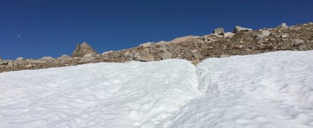
I slept in and had a leisurely morning. Strider from Mt. Williamson Base Camp would be meeting me at the Onion Valley trailhead at 12:30, and it was less than an two-hour hike away. So I had a bit of yoga and a bit of fishing and a bit of meditation practice. There’s a large flat rock that overlooks Gilbert Lake, too far and high above the surface to fish from, but quite a nice spot for yoga and meditation if you’re in the neighborhood.

Strider met me at the trailhead with her truck and her dog Indy. I treated myself to Strider’s resupply package before my trip…so she picked me up (and any other Base Camp guests) at the Onion Valley Trailhead and took me down to Independence, where I had a room at her hotel for the night.

Indy+sunbathing+at+KP+

(Indy! Photo from Strider’s website.)

As she checked me in, I noticed a magazine article posted on the wall with her photo in it. I told her she looked like a model, and I wasn’t wrong…she was! She made a career change and bought the motel in 2013, and she’s made quite a name for herself in the Sierra community. She’s also a highly accomplished long-distance hiker herself. She has completed the John Muir Trail every year for over 20 years…and more than once she’s “boomeranged” it, turning around at the end and hiking back to her starting point. She’s amazing.

20170904_ - 30

Me and Strider.

My buddy John was there to greet me too! He and his partner Glenn were on a Labor Day trip in the Eastern Sierra and were able to drop by Independence to say hello. (and deliver some emergency fuel canisters too)

20170904_ - 8

Me and my buddy John.

And then it was time take care of my to-do list. When you’re doing a thru-hike, you have to take advantage of every minute you have in town. You’ve got stores, food, wifi, cell service, running water…take advantage of it.

First, shower and food. Get those out of the way.

20170904_ - 9

Once you’re clean and fed you can concentrate on checking all your gear and resupplies. Empty out your backpack. At Strider’s place, you put your laundry in a basket and drop it off at the front desk. They’ll take care of it and deliver it back to your room. You want to do this first because it will take a couple hours.

20170904_ - 20

Then charge all of the things.

20170904_ - 21
Hang up any clothes that aren’t getting washed (rain gear, down) so they can air out. Same for your sleeping bag. Shake out the dust and dirt, turn it inside out and air it out.

20170904_ - 16

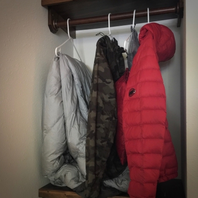
Shake out your tent and rainfly. I set mine on the floor under the AC so it could get some air too.

20170904_ - 17
Take care of any clothing and gear repairs that need to be done, because glue and tape need time to set and dry. My gaiters attach to my shoes with a bit of Velcro that was starting to come loose. (This is why you should always carry a small tube of Super Glue in your kit.)

20170904_ - 18
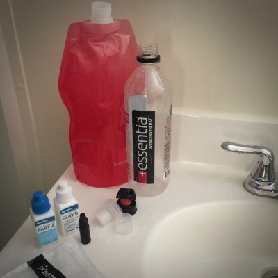
Wash and sanitize your water bottles, water purification kit, lens cases, toiletries, etc.

20170904_ - 19

Give your cook kit and your utensils a good wash too.

20170904_ - 24

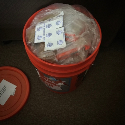
Next thing to do is open your resupply bucket and pack your bear can. My next resupply bucket was 6 or 7 days away, so I would have to pack my canister to the brim with food.

20170904_ - 15

My method is to bag all my breakfasts together, all my snacks together, and all my dinners together. Then when I get my bucket, I make a pile for each day that I plan to be hiking and make sure each pile has one breakfast, several snacks, and a dinner. Here’s all my food for seven days laid out in columns, one column for each day, starting with breakfast at the top of each column and ending with dinner at the bottom.

20170904_ - 26
Then you can pack each day into its own plastic sack, and pack the daily food sacks into the bear canister with the next day’s food on top. I also pack a separate sack of provisions…coffee, sugar, dry milk, olive oil, candy, cough drops…everything that’s used daily. That also lives in the top area of the bear canister. I like using poly/nylon oven bags to store my food for each day. They’re lightweight and very strong.

Last thing to do is resupply your toiletries and other expendables. Hopefully you thought to put those in your resupply bucket as well.

20170904_ - 28

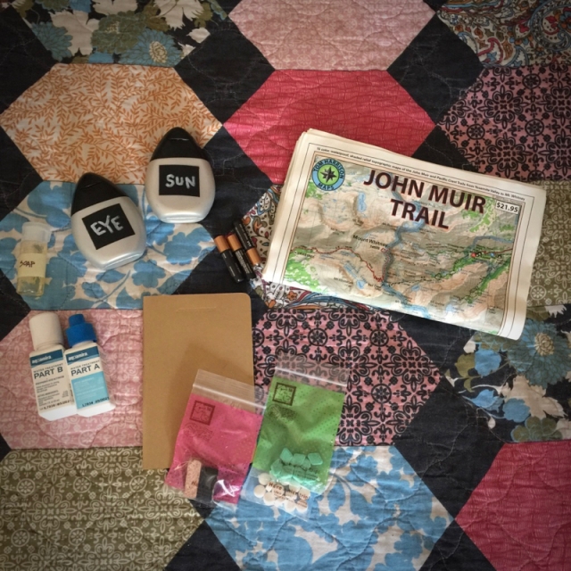
Clockwise from top right: maps for the next trail section, toothpaste and mouthwash tabs, incense and charcoal, new journal, Aquamira drops, soap, lens solution, sunblock, AAA batteries

Once all that is done, you can relax!

After I finished dealing with my supplies, I put on my flip-flops and took a short walk around town. (There’s only one road through Independence so it didn’t take long.) I recommend the salads and pizza at Owens Valley Growers Co-op, and the sandwiches at Still Life Cafe.

Still Life Cafe is an interesting anomaly. It’s been run by a French family for over 20 years. (though I don’t think it’s been in Independence the whole time)  The original proprietor works in back making sandwiches and burgers and her daughter is out front running the restaurant. There’s jazz music and art books and mood lighting, quite a change from the rugged outdoors.

Wherever you go in Independence, you’re bound to meet other hikers and outdoor enthusiasts. When I got back to the hotel I met a fellow guest, Jason. (Pinoy siya rin!) He and his girlfriend were in the middle of their own NOBO JMT trip (northbound John Muir Trail) and we hung out for a bit to trade stories. Jason is also an amazing photographer…check out his website.

I made my last phone calls and looked up a bunch of stuff on the internet while I still had service. My day in Independence was over and before I knew it I was snug in bed. (enjoying that awesome quilt)  The next stretch of trail would be the longest one yet without a town stop or a resupply bucket. I fell asleep full of anticipation.

20170904_ - 29

Trail Food: How to Identify/Cook with Wild Onions

I love wildflowers, but one in particular makes my mouth water. I want to thank my friend Emily (whom I met on the High Sierra Trail) for pointing these out!

IMG_1554

Allium validum, “swamp onion”.

This is Allium validum, or “swamp onion”. It’s pretty common in the Sierra Nevada but it’s also found in the Rocky Mountains and the Cascade Range. They usually grow next to creeks, especially those made of snowmelt. They seem to like cold water. The flowers are pretty easy to identify but if you’re still not sure, just take a whiff…they smell like green onions from the store, except they’re a bit more pungent and wild. I once had to refill my water bottle from a spring dripping through a patch of these and the smell and flavor of onion was actually very strong in the water.

IMG_1541


Here’s how I harvest and cook with wild onion. The part you want is the firm, purplish bulb section at the bottom of the flower stalk, just above the roots, so when you pull up a wild onion you want to reach down close to the soil and try to pull up some roots with it. Cut the roots off and the green leafy tops, leaving the purple bulb. It might remind you of the color of shallots or red onions. Apparently the entire plant is edible, including the leaves and flowers, but I’ve only tried the bulb.


Get your knife out and remove the outermost layer of the bulb, then slice the onion as finely as you can.


Heat about a tablespoon of olive oil in your cookpot and saute the onion. Word of warning: when the onion hits the hot oil, it will smell AMAZING. You probably don’t want to do this right next to your tent since every bear downwind for a couple miles will smell it.

IMG_1457

Once the onion is tender, add as much water as you need to cook your meal. (In this case, I’m making the old standby, Peanut Sauce with Noodles, so I filled the pot with water.) Then continue to make your meal using the onions and water. If you like onions, you’ll love this.

If you enjoy cooking as much as I do, you come to miss cooking for yourself on long backpacking trips. Most of the cooking I did on the JMT was of the “boil water, add food, stir” variety. So it’s nice to harvest something and cook it while you’re on the trail. (Medical note: Emily advised me that wild onions are high in selenium, so people with thyroid issues should eat these in moderation or avoid altogether.)

HST/John Muir Trail: Day Thirteen, September 3

This wasn’t my first time to Kearsarge Lakes. The first time I was there, in 2016, my buddy John and I tried getting to the uppermost lake. It was snowy and cold and we didn’t make it, but we got close enough to get a nice view of University Peak.

Kearsarge Lakes from a different trip in 2016…the uppermost lake is below University Peak, center horizon.

This time I would not be denied. I got up early to bag the upper lake. The Kearsarge Pinnacles that overlook the basin make for some pretty dramatic sunrise photos.

Getting to the lake required a lot of rock scrambling and navigating through wet meadows. Totally worth it, because wet meadows means wildflowers.

20170903_ - 6

The uppermost lake was icy and isolated. I was surprised to see a few golden trout in the water. It was a beautiful place for sitting on a rock and appreciating the unfolding of another fine Sierra Nevada morning.

20170903_ - 10

Uppermost of the Kearsarge Lakes.

On the way back to my tent I found some bear scat and I wasn’t surprised. These isolated High Sierra meadows with lots of water are perfect bear habitat. Later on in my trip some guys told me that a bear had tried to get in their tent while they were camping here. (I think they said they had all their stuff in their tent since it was raining, or something like that…I presume they meant they had food and/or toiletries with them.) They were hiding in their tent yelling at it to go away but it really wanted to come in, ha ha!

I’ve had a couple of run-ins with bears and that’s enough for me. They are beautiful creatures and I love to see them from a distance.

I went back to my tent, packed up quickly, and headed up Kearsarge Pass. It was starting to rain and I wanted to get up and over before the weather got crazy.

20170903_ - 16

From the top of Kearsarge Pass, looking back. Kearsarge Pinnacles in the center, overlooking the lakes.

20170903_ - 18

Looking back at Kearsarge Pass after crossing it. Busy weekend!

Right after I crossed the pass, I ran into Frost, the guy who hitchhiked with me in Lone Pine! He had spent the night before in Independence and was on his way back to the trail. I was pretty sure I wouldn’t be able to catch up with him, he was clearly hiking much faster than I was. Sorry no pics!

Between Kearsarge Pass and Independence there are a ton of beautiful lakes, and the Kearsarge Pass Trail goes by all of them. Since I’m going to have to talk about this hike again on my way back to the trail in two days, I won’t talk about the lakes now, except to say that I picked Gilbert Lake for my last campsite before town. The fishing is AWESOME at Gilbert Lake…caught a couple of fat rainbow trout there.

Independence tomorrow! The town that is.

20170903_ - 25

Gilbert Lake.


HST/John Muir Trail: Day Twelve, September 2

It was a cold night, but that’s to be expected when you’re sleeping at 12,000 feet. I got up before sunrise and packed up as quickly as I could.

Heading up toward Forester Pass:

20170902_ - 1

20170902_ - 2

20170902_ - 4

You can see the trail cutting across the cliff foreground left.


Climbing Forester Pass on the south side is pretty straightforward. No “false summits”…places where you think you’re about to cross the pass and see the other side but when you turn the corner you realize there’s more climbing to go. From the south, you just keep climbing and climbing and all of a sudden you come to the crest and…the view!

IMG_1055DCIM100GOPRO

When you cross Forester Pass you also cross the Kings-Kern Divide. On the south side, you’re in the Kern River drainage. All the snow on that side melts into the Kern and all of its tributaries. On the north side, all the snow drains into the Kings River.

You can tell from these photos looking north that the JMT has to climb/descend several mountain ridges on its way to Yosemite.

20170902b_ - 120170902_ - 7Version 2

There were a few snow crossings but nothing very dangerous. I just had to keep from being distracted by the views.

20170902_ - 1120170902_ - 1220170902_ - 15

The rest of the day was a walk in the park, mostly downhill. I descended the north side of the pass, passing a bunch of southbound JMTers as I went. It was a chilly morning, and beautiful. The light felt like gold.

DCIM100GOPRO

Can you find me in this photo?


I passed a trail sign where some JMTers had attached a note warning other hikers about some food-accustomed bears in the area. More about this bear/bears later. (Insert ominous music here.)

Bear warning!

When I got to the Kearsarge Pass trail, I exited the JMT again toward the town of Independence, where my 2nd resupply bucket and a bed would be waiting for me in two days. Along the way I would pass through the Kearsarge Lakes basin.

I took a dip at Bullfrog Lake. No fish here…CA Department of Fish and Wildlife removed all the fish since they prey on tadpoles. DFW is trying to protect the Sierra Nevada yellow-legged frog)

I stopped for the night at the largest of the Kearsarge Lakes. I arrived to find it pretty crowded with campers for the Labor Day weekend. The Kearsarge Lakes basin isn’t too far from the town of Independence so I wasn’t really surprised, but I hadn’t counted on it. Anyway, it’s still a pretty spot.

20170902_ - 24

20170902_ - 25

Kearsarge Lakes.

Tomorrow, Kearsarge Pass and more lakes!